Wednesday, 9 March 2016

A new phone or Not - and the Cicret

I blogged this about a year ago, I think the Cicret its so cool, I want one, but as always I shall wait, I currently have a simple iPhone 5 and for the most part it does what I want, but I live on a cusp between Apple and Google, its manageable but some time inconvenient, so when I started receiving calls about my contract coming to an end, I started to thing about what I shall go to next, I must admit, a Google Nexus is becoming interesting,  but so is almost all of the current google Android phones, so I was particularly pleased to see this smart little devise is Android based.

I still have not made up my mind, after all my current phone the Apple iPhone 5 works very well, so perhaps a break from the spiral of phone purchase, maybe I stay with Apple, the local Apple store is so good, and Google is,,,, well absent from the high street, and this also works with Apple, oh the choice I face.


Tuesday, 8 March 2016

Apple Campus Architecture

It can't have escaped your attention Apple are building a new Campus, there are loads of videos on Youtube, but this article on Mashable is the most up to date.

One thing that is not really in this article is the shear scale of the project, something the video's below show.

 I looked up the plans again and can't wait till its opened and finished, but one thing I noticed was the small circular building at the bottom of the plot that seems to have the roof held up with just the glass, you have to read the article, Fosters have in my book broken the mould, and made glass so much more a structural item, I can't wait to see the final views, although take a look at the video below, I think this building is now complete, and roof on. See the latest video at the end of this Article.


There is a latest video, made in March 2016 what a difference a year makes


Weather seasons and Shadow Length

I am reversing things today, normally I add my little bit on todays photo last, but todays photo is the main theme of todays notes. It was, whilst I was driving back from Tenbury Wells, or ir it just Tenbury, that I noticed that the hop fields are being planted and restrung, so what I here you ask, well its all part of the weather, and the natural cycle of things, and my natural love of all thing beer related.

I have mentioned the use of weather as part of detailing so many times, but driving along I just saw the fields and the long rows of poles with the long strings that the plants climb up, that in its self was so worth stopping for.

I have a moleskin full of things to mention, but I just liked the idea of the season changing, plants waking up, and a change in Temperature, although It's probably short lived and we will get freezing weather before the weekend, strange weather is afoot, but one thing thats not going to change is the length and angle of shadows I say not change but as we know each day brings a predictable alteration something we still fail to predict in the weather !, believe it or not I saw the poles first thing in the morning on the way out and the shadows were long and thin, but on the way back the shadows had moved and shortened. I thought of so many things in that instant, my lecture on the Earth spinning and moving about the sun, and lat and long, and the long shadows we now see on so many buildings.

Shadow is a fundamental part of Architecture, yet so often it a part of design thats short lived, we thing about it early on and thats it, but its something that will be with a building to the last seconds of its life, and will change as new buildings are added to neighboring plots, and the effect on its appearance and performance will change, so will the feel or what I call the sole of the building.

I want my students to take time at some point in the year to sit and watch shadows and their effect on a building, I doubt they will have time, but one can hope.

Monday, 7 March 2016

Tree Preservation Order

For so long I seemed to work on large projects devoid of trees, even when I worked in insulation, supporting Styrofoam insulation, the only trees I saw were growing in rain water gutters and I might add, doing very well. But they were not of interest to the local authority, and certainly not worth saving, it was only in later years when I started the extensions that I came up against TPO's, or Tree Preservation Orders.

So what are we talking about, well trees have certain rights, the planning portal has a lot on this subject, but the general opening page gives it straight :

A Tree Preservation Order is an order made by a local planning authority in England to protect specific trees, groups of trees or woodlands in the interests of amenity. An Order prohibits the:
  • cutting down
  • topping
  • lopping
  • uprooting
  • wilful damage
  • wilful destruction

of trees without the local planning authority’s written consent. If consent is given, it can be subject to conditions which have to be followed. In the Secretary of State’s view, cutting roots is also a prohibited activity and requires the authority’s consent.

Local planning authorities can make a Tree Preservation Order if it appears to them to be ‘expedient in the interests of amenity to make provision for the preservation of trees or woodlands in their area‘.

Authorities can either initiate this process themselves or in response to a request made by any other party. When deciding whether an Order is appropriate, authorities are advised to take into consideration what ‘amenity’ means in practice, what to take into account when assessing amenity value, what ‘expedient’ means in practice, what trees can be protected and how they can be identified.

In my experience, local authorities seem to take a view that all trees are subject to a TPO, so best to check, before removing it, and don't forget, this applies both to clumps of trees, and hedge rows.

You might also want to get hold of a local Arboricultural Consultant  a tree man/Woman, who will advice on the species, and how to deal with it, the link I have added is to the National Association for Arboriculturalists.

This also heads directly into BIM, for a long time I surveyed trees for local parks and private clients, we added tree symbols with a lot of data attached, from simple species and latin names to tree height, canopy spread, trunk size, and general condition, plus it was linked to a massive database for the various reports made over the years, we even made a dead or died field, this tree was then hidden away, but not forgotten, as we so often had to print maps with dead trees on, colour coded for years or months that they died, showing disease patterns across estates. Exporting this information both as IFC, but mostly as Cobie of spreadsheet files.

We also noted the types of trees that used or consumed a lot of water, Black Popular for instance, very interesting in location of buildings and trying to remove them, the effects on the construction can be,,,,,, interesting. But more on this in a new blog I am planning.

There is a lot to cover in this subject, so my suggestion is to head over to the planning portal and read.

Friday, 4 March 2016

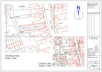
Location & Site or Block Plan

Most if not all planing applications require both a location plan and a block or site plan.

The Location plan, as the name suggests, locates the site, it should be at a scale of 1:1250, or if its a really big site, then 1:2500, it should be based upon an up to date OS map,  The Planning portal says it should be on an A4 sheet, I can't remember doing this ever, all mine are on A3 or larger.

It should show sufficient road, road names, houses/buildings to locate the site, a north point and the site outlined in Red, I tend to use a poly line with a nice thick pen, and a little tone to shade the area.

A blue line can also be used to show land owned by the client that is close by or adjacent to the site in question.

The Site or Block Plan should be drawn at a larger scale I tend to use 1:500 although it can be 1:100 or 1:200, it should show the proposed development in relation to the site boundary again it should show north. Again it should show relevant buildings and road, and names, rights of way, trees hard surfacing boundary treatment.

I tend to always buy OS digital maps online from my provider, its easy to do, and I get the benefit of being able to import it directly into my cad package easily. they always come as dwg files, and are always geolocated. Be aware though, OS maps are in metric meters, so as we almost always use mm to draw in, they need conversion.

So often the maps do not have all the road names on then, so I try and use google maps to supplement the information.

The title block I use, should also have the scales of the map, and its relation to the page size being used, ie 1:500@ A3, so often we use pdf files to submit to the planners and this is a requirement, I have seen plans returned because its not on the title block.

I also like to see the OS co-ordinates to the north point together with a sun rise, sun set path added to the north point, with lat and long of the site centre, although I so often forget to do this.

When using OS maps for planning we should show the Crown Copt right, I tend to do this in the notes section of my title block

All this and a little more can be found on the planning portal info page on using maps


Thursday, 3 March 2016

How far can we take 3D

How far can we take 3D, I had a conversation with a planning professor, recently, and he had no idea as to the use of even existence of Point Cloud, and was only just aware of how the industry is heading towards 3D and BIM, reason, he still received most if not all his planning applications the old way, simple elevations and plans.

I started to explain how the industry is heading, the use of 3D and BIM how data rich our files are now, by just clicking onto any portion of the structure a full spec of that material will appear, why do I need to make flat 2D drawings.

His first argument was the way they have a responsibility t the general public to take in comment, if they can't read the drawings,,,,, etc, my argument was to show a 3D image and compare it to a flat 2D elevation, the 3D image was easier to read.

Next point cloud, again he was astounded that we were at such a level, as we all know the street scene to a planner is the first point of reference to a planning application, how will it fit, adding our 3D image to a point cloud 3D render made the difference.

So the question is can we move forward, do flat 2D elevations and old style specs still have a place in planning, or should we be pushing to to a more 3D world. I like to think so but there will be stiff opposition the paper world planners still live in, the files being electronic, the public, how will the planner read the files, Solibri being the obvious answer.

Adding building Regs to the same list comes a very near second, but I am glad to say, their interaction with the CAD files we use is in my experience a little more up market than planners. but paper is still king, this we need to tackle.

As for the photo, see yesredays blog on weather, I just love to flow of weather round the planet,

Wednesday, 2 March 2016

Global Warming myth or fact

You might well ask if global warming is myth or fact, simple answer fact. One again the weather is showing an increase in temp, although you might not believe it, I walk my dog most days, and believe me some times I arrive back home thinking, its a myth, I am so cold.

But yu only have to look at the global weather data to see whats realy going on. This excellent article on Slate, is a realy good round up with an excellent picture of the globes weather temps, together with some great stats and graphs.

OK so I stole the same photo for today, I hope the original author ric Holthaus forgives. The article is well written in that he outlines the problems and gives some excellent links for further reading and research. If you have time watch the Geoengineering video, its a look at the basic problems and some ideas to fix the damage.

I have long stated that as technologists we need to study weather, its what we detai against, and some of the norms and standards we used to use are now wrong, and its up to us to step back and rewrite some of these standards.